 ×
×
July 24, 2026
On a sloped parcel above a lake in early November, the ground on the north side stays soft two days after rain and the south edge dries by noon.
What a designer notices in the first hour is rarely on the survey. The angle of light on the west stand of firs at three in the afternoon. Where cold air drains at dusk, and where it pools. Which trees hold the view when the leaves are off, and which ones only close it in July. The sound of the road, which carries differently at six in the morning than at six in the evening.
The Pritzker laureate Glenn Murcutt has been known to camp on a site before drawing, per ArchDaily’s account of essential site-analysis practice. The reason is not romance. It is that a parcel behaves differently across a day and a season than any document can hold, and the design decisions that follow tend to be the consequential ones.
Architectural site analysis for custom homes is the study of a parcel’s physical, climatic, ecological, and regulatory conditions before schematic design begins. The accepted arc runs research, then analysis, then synthesis, and most published guides stop there.
The trouble is that a filing system for data does not produce a house. Causation does. This slope, therefore this foundation. This wind, therefore this courtyard. This view, therefore this long axis. Most guides to architectural site analysis residential design read as inventories of what to collect. The more useful question, and the one this piece is built around, is what each reading forces the design to do next. Every section below moves from a reading to a move, not from a category to a bullet.
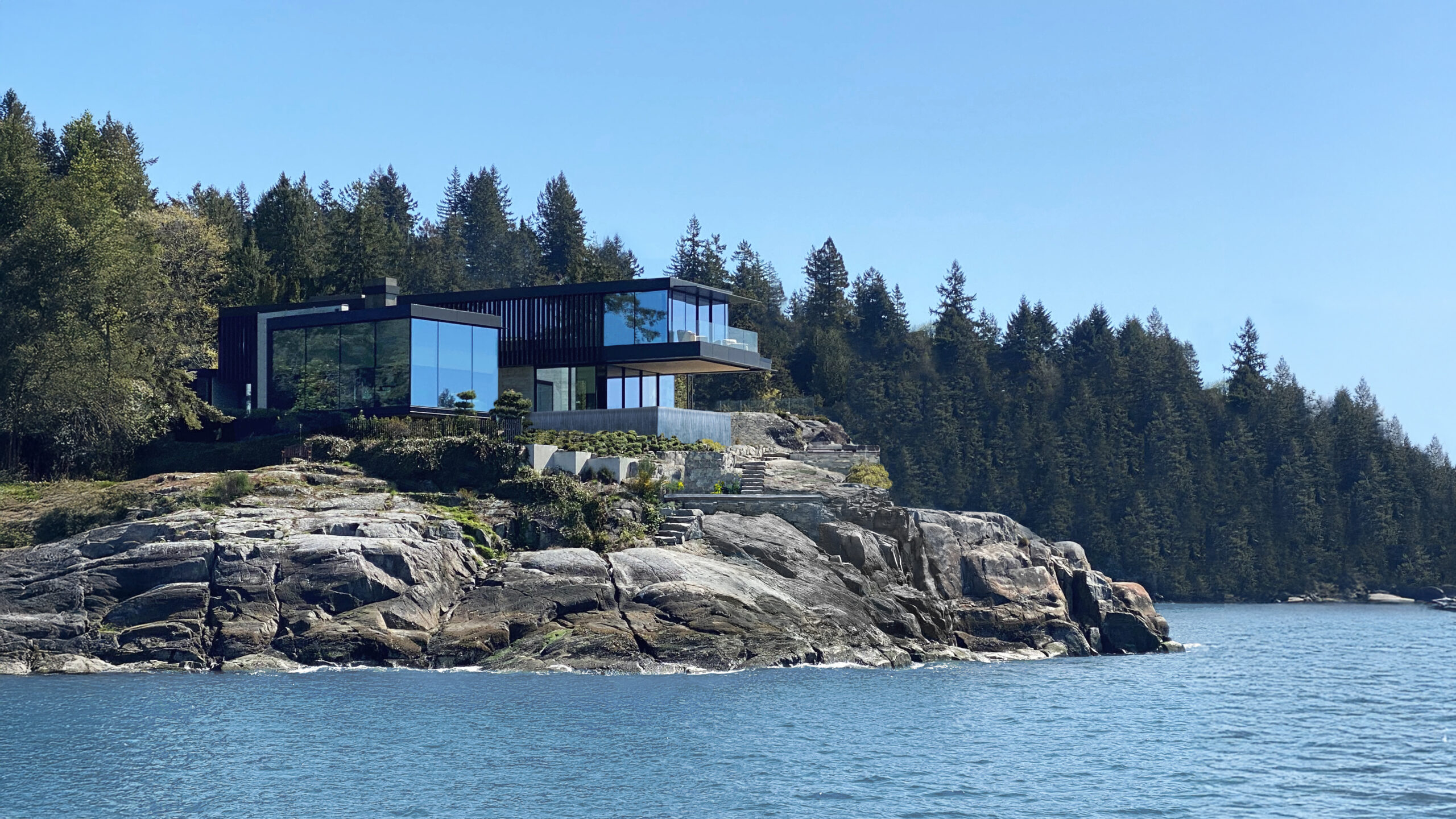
On the Waterfront Pavilion, a Pacific Northwest cliffside parcel was initially considered unbuildable. The stone peninsula was carved with controlled blasting to create a stable foundation, and rather than concealing the subsurface condition, bedrock was left exposed inside the living areas as an architectural element. A green roof, planted with native vegetation, helps the structure recede into the forest when viewed from above. The project was recognized with a Rethinking The Future Award in 2024 and an IIDA INAward in 2021.
On most sloped lots the ground shape decides more than the footprint. It sets the choice between cut and fill, stepped foundations, walkout basements, and slab-on-grade, and it sets the elevation of the main floor relative to grade. Where water wants to run across a parcel decides where the house cannot sit. Fifty-year and hundred-year flood levels shape floor elevations on any lot that touches a shoreline or a low point.
The failure modes worth naming are the ones that surface mid-build. Hitting rock a foot shallower than the drawings assumed. An unmapped septic line under the proposed garage. A perched water table that turns a lower level into a maintenance problem. Early topographic reading tends to prevent these. Occasionally, as on the Waterfront Pavilion, the geology becomes the reason to design the house you would not otherwise have thought to draw.
The first decision that follows a sun-path reading is usually the long axis of the house.
The rubric worth carrying is a set of sun studies at roughly nine in the morning, noon, and three in the afternoon, run across the summer solstice, winter solstice, and the equinox. That produces nine snapshots that together describe the parcel’s light behavior for the year. Where the summer sun hits a west wall for three hours at four in the afternoon matters, and where the winter sun stops reaching a north-facing kitchen counter by half past one matters more. Passive-cooling and natural-ventilation moves are drawn from these readings rather than specified afterward.
On the Mercer Island Modern Residence, orientation to Lake Washington and the sun path set the water spine that runs through the plan. A reflection pond at the entry, a lap pool at the core, and an infinity spa at the far edge of the property were sited so light reads on water at different hours through the day. The kitchen wants the light the family actually uses it in, not the light on the elevation drawing, and until a designer knows how a household lives on a Tuesday morning and a Saturday afternoon, blanket rules about southern exposure tend to be guesswork. Passive strategies follow from that reading, not the other way around.
The Evergreen Point Sanctuary carries a courtyard at its center, drawn from an Asian courtyard vernacular. The typology regulates temperature passively, allowing cross-ventilation during warmer months while retaining heat in winter. It reads as a garden. It performs as an environmental strategy.
Prevailing wind directions shift by season on almost every parcel, and cold-air drainage on a slope behaves differently at three in the morning than at three in the afternoon. Cross-ventilation depends on aligned openings on the pressure and lee sides of a house. Courtyards work because they trap warmth and move air at the same time, if the openings are placed against the actual wind rose rather than a generic one. Decibel readings during high-noise periods, taken at several points on the parcel, are a plain and undervalued procedure.
Belvedere Point sits on a rugged coastal edge, where salt air, cliff-driven wind, and long west-facing exposures set envelope choices differently than an inland lot would. Board-formed concrete and wood-clad aluminum were chosen for durability against saltwater mist. West-facing terraces catch sunsets over Puget Sound, and the plan’s cross-ventilation moves come from the coastal microclimate rather than from a specification sheet. On coastal lots the wind reading and the envelope decision are often the same conversation.
Drip-line offsets, protected-species ordinances, and neighborhood tree covenants move footprints. They do not simply appear on the landscape drawings after the house is drawn. A grandfather cedar with a wide canopy can pull a proposed garage ten feet to the north, which then changes the driveway approach, which then changes the entry sequence.
Native and drought-tolerant palettes are a starting point, not a finish. Habitat corridors, salmon-bearing streams, and shoreline vegetation buffers appear on many Pacific Northwest lots and are read on the first visit rather than the tenth. A protected tree found on final permit review is the kind of surprise that costs six weeks of drawing and a difficult client conversation, both of which an early walk with an arborist tends to prevent.
On the City Home Remodel, the garden was replanted as an ornamental pine forest and the landscape architecture merged with the building and its interiors, with a sunken Japanese bath opening into reflecting ponds. The standard industry sequence, architect draws the house and landscape designer arrives with a schematic six months later, tends to produce a garden that decorates a building. Bringing the landscape designer to the first site walk is the reason gardens finish what the architecture started rather than apologize for it.
A client once described the view from her parcel as “the whole west side.” Standing on the site with a phone compass, the actual angular corridor that carried Puget Sound, framed on either side by neighboring rooflines and a stand of firs, spanned about forty degrees. Everything else on the west side was a fence, a neighbor’s dormer, or sky. That reading changed the plan.
A view has a foreground, a middle ground, and edges, and framing decisions determine window sizes, ceiling heights at the view wall, the long axis of the plan, and where thresholds sit. Sight lines from adjoining properties into a primary suite are the failure mode almost no one discusses, and they are read at the same visit. On Belvedere Point, glass bridges and floor-to-ceiling walls were organized around the specific corridor to the Sound rather than around a generic west orientation. On the Medina Zen Garden the structure was nested into a natural slope to draw the eye through architectural water features toward Lake Washington and the city skyline beyond. A view revealed as a sequence at chosen thresholds tends to move people more than a view dumped on a visitor at the front door.
Setbacks, height limits, easements, floor-area ratios, shoreline overlays, historic districts, and character covenants define the buildable envelope before a single wall is drawn. Reading these early is not administrative caution. It is the outer frame every subsequent decision fits inside.
On the Cypress City House, the design was described honestly as a creative exercise in analyzing the program while staying within required city setbacks, height restrictions, and character covenants. On the Sam Hill House, historic-society guidelines shaped which walls could be moved and which windows could be added, and the interior was reconfigured with those limits already understood. Jurisdictions work differently. Washington State counties, shoreline jurisdictions, and Vancouver, BC each have their own rules, and local counsel matters. Clients often treat zoning as the thing the architect handles at the end. The parcels where a covenant on the neighbor’s driveway easement constrained the design are the ones where a first-visit conversation would have saved weeks.
In most architecture contracts the client supplies the initial site information, the boundary and topographic survey, the geotechnical report, and soil testing. The design team interprets those documents and coordinates the consultants who produced them.
The money spent on a proper survey and a geotechnical report before drawings begin is often the best-spent money on the project. It removes the largest sources of mid-build surprise. The money spent on a downloaded site-analysis template, by comparison, is usually wasted, because the template does not know your lot.
On the Pacific Spirit Art Estate and Garden, koi ponds and reflection pools were framed by large glass doors and windows, and the exterior gardens with their sculptural elements and flowing water carried the same material language as the interior. On the Willow Stream House, the path into the private inner courtyard almost feels like an interior experience, and the courtyard sanctuary blends the indoor and outdoor moments rather than announcing a transition between them.
Those results are difficult to reverse-engineer. When the same reading of the ground produces the driveway approach, the room orientations, the material palette, and the garden in one act, thresholds get resolved rather than negotiated later. The stone in the entry can continue as the stone in the garden wall because the two drawings were made in the same room. The standard model, three consultants briefed sequentially off a schematic, tends to produce houses that read as the sum of three good drawings. A house designed from a shared reading of the ground tends to feel like it was already there, which is difficult to fake later. This is why the integrated approach matters at site-analysis stage, not just at construction documents.
How long does a site analysis usually take on a custom home lot?
A few days on a straightforward lot, several weeks on a difficult one. Complexity is the driver: slope, shoreline overlays, protected trees, and jurisdictional review windows each add time. How much documentation the owner already has, and how recent it is, matters too.
Do we need a survey and a geotechnical report before design starts?
In most architecture contracts the client supplies both. It is worth doing early. A proper boundary and topographic survey and a geotechnical report before schematic design begins is often the best-spent money on the entire project, because it removes the largest sources of mid-build surprise.
Can a good site analysis reduce the cost of the build?
Often yes, though the mechanism is prevention rather than a line-item saving. Early readings tend to catch the conditions that would otherwise trigger redesign, permit resubmissions, or foundation changes during construction. The savings are real but they are hard to size until the specific lot is walked.
Does site analysis matter as much for a renovation or a teardown as it does for a new build?
Yes, and sometimes more. The existing structure and its history become part of the reading, alongside the ground. On the Sam Hill House, an early twentieth-century mansion, the site and the building’s own preservation constraints were read as one condition, and the reinvention followed from that combined reading.
What if the lot has protected trees or a shoreline setback?
These constraints tend to move the footprint before schematic design begins, which is why they are read on the first visit, not the tenth. Local ordinances vary, and the honest answer for any specific lot depends on the jurisdiction and the species involved. Bringing an arborist and a designer to the same walk is usually the right first step.
When should we bring the landscape designer into the conversation?
On the first site walk, alongside the architect and interior designer. The garden is drawn on the same day the house is, or it is drawn late. The trees are already speaking on the parcel before the house has been imagined, and they tend to say things the architectural drawings will need to hear.
Beginning your custom home with the land in mind
Garret Cord Werner is a full-service architecture and interior design studio that has been developing architecture, interiors, and landscape as a single, unified vision since 1996. The firm is rooted in decades of hands-on building experience, carried forward from a family construction heritage, and that background shapes how a site is read in the first hour on the parcel. Every project moves from that shared reading through spatial planning, custom furnishings, lighting, hand-woven rugs, and curated art, so the finished house feels of its ground rather than placed on it.
If you have a lot in mind, or a lot in hand, and this way of working resonates, we would welcome the chance to walk it with you and talk through what its conditions might become.


